How To Get There |
|
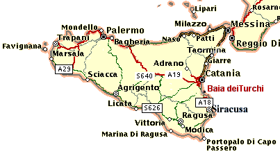
CLICK ON "Baia dei Turchi" and look for "Cozzo dei Turchi" !!! (it is a hill just behind)
The closest airport (15 Miles) is the Catania Fontanarossa Airport (CTA).
1) Take the ring road of Catania (Tangenziale Ovest) toward SIRACUSA.
2) Go straight and proceed on Highway (Autostrada) Catania-Siracusa.
3) After the first tunnel, at about 2 km, there is the first exit (Ragusa-Lentini-Carlentini): now take this exit.
CAUTION HERE: DO NOT FOLLOW ANYMORE direction Ragusa-Carlentini BUT direction SS 114 - SIRACUSA (keep left).
Proceed until you reach the SS 114 (the old state road Catania-Siracusa) and proceed towards Siracusa-Agnone Bagni.
4) After a bend left uphill, you will see an Esso petrol station and, about 1.5 km later, a small overpass. The exit to Brucoli is there.
5) Take the exit for Carlentini-Brucoli, Brucoli direction (you must drive on the overpass!).
6) Proceed for 3.9 km from the overpass, passing the exits for "Castelluccio", "Baia del Silenzio", "Baia del Gambero." You will see on your left a small street that runs through an orange grove (there is a small sign "Baia Arcile"). Take the street and go down to the sea.
7) Now, after 1.3 km you will find a green gate. Now you are at the Baia dei Turchi.
These are the GPS coordinates:
+37° 17' 9.77", +15° 9' 37.92".
South-Eastern Sicily. In order to find "Baia dei Turchi" look for Cozzo dei Turchi, then zoom (in or out) the image! (Remember: Cozzo dei Turchi is a hill just behind the Bay)
Detailed directions to print!!!
|HOME | THE VILLAGE | HOW TO GET THERE |SICILY | ITINERARIES | RESERVATION | PRICES | CONTACT US |